VRoadworks - Interactive Data Visualization for Coordinating Construction Sites in Virtual Reality

PubDate: September 2019
Teams: Universität Hamburg
Writers: Manuela Uhr;Sina Haselmann;Lea Steep;Chia Bretschneider;Joschka Eickhoff
PDF: VRoadworks - Interactive Data Visualization for Coordinating Construction Sites in Virtual Reality
Abstract
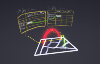
This work describes the use case, design and development of a virtual reality application for the visualization of multidimensional road works data. For coordinating construction sites affecting roads and traffic, spatial and temporal dependencies need to be considered. In widely used 2D visualizations such as Gantt charts and digital map tools, the relevant data and dependencies cannot be shown simultaneously or in a well-associated way resulting in high cognitive load. Therefore an interactive 3D visualization with multiple map layers in virtual reality was designed and developed. The usability of the prototype was evaluated in a small user study and expert interview.