3D Reconstruction & Assessment Framework based on affordable 2D Lidar

PubDate: Sep 2018
Teams: Technical University of Munich;Tongji University
Writers: Xueyang Kang, Shengjiong Yin, Yinglong Fen
PDF: 3D Reconstruction & Assessment Framework based on affordable 2D Lidar
Abstract
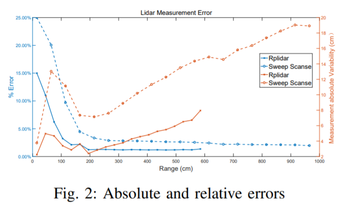
Lidar is extensively used in the industry and mass-market. Due to its measurement accuracy and insensitivity to illumination compared to cameras, It is applied onto a broad range of applications, like geodetic engineering, self driving cars or virtual reality. But the 3D Lidar with multi-beam is very expensive, and the massive measurements data can not be fully leveraged on some constrained platforms. The purpose of this paper is to explore the possibility of using cheap 2D Lidar off-the-shelf, to preform complex 3D Reconstruction, moreover, the generated 3D map quality is evaluated by our proposed metrics at the end. The 3D map is constructed in two ways, one way in which the scan is performed at known positions with an external rotary axis at another plane. The other way, in which the 2D Lidar for mapping and another 2D Lidar for localization are placed on a trolley, the trolley is pushed on the ground arbitrarily. The generated maps by different approaches are converted to octomaps uniformly before the evaluation. The similarity and difference between two maps will be evaluated by the proposed metrics thoroughly. The whole mapping system is composed of several modular components. A 3D bracket was made for assembling of the Lidar with a long range, the driver and the motor together. A cover platform made for the IMU and 2D Lidar with a shorter range but high accuracy. The software is stacked up in different ROS packages.